ESSO - Indian National Centre for Ocean Information Services
(An Autonomous Body under the Ministry of Earth Sciences, Govt. of India)
Services
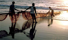
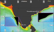
About 7 million people living along the Indian coastline, spanning over 8100 km, are depending on fishing for their livelihood. Locating and catching fish is always a challenging task. Often, the search for fish ends up in spending considerable time and resources, thus increasing the cost leading to low profitability. A reliable and timely advisory on the potential zones of fish aggregation will benefit the fishing community to reduce the time and effort spent in searching the shoals of fish, thus improving the profitability and hence, the socio-economic status.
The Ministry of Earth Sciences (MoES), earlier known as the Department of Ocean Development (DOD), initiated Marine Satellite Information Services (MARSIS) programme in June 1990, to device methods to use the oceanographic data, especially the satellite data to address the issues involved with the usage of oceanic resources. One of the objectives of MARSIS was the usage of remote sensing data and its applications for the management of coastal oceans and to devise the methods to use the satellite data to harvest food from sea. At this juncture, the scientists from marine sciences, remote sensing and fishery science collaborated to develop a technique that can use the remotely sensed sea surface temperature (SST) to identify the locations of fish aggregation. The concerted collaborative efforts of scientists from Earth Sciences, space and fishery science have resulted in successful demonstration of the application of satellite derived data for the demarcation of "Potential Fishing Zone (PFZ)" as a proxy to potential shoals of fish aggregation in the Indian waters.
INCOIS Services
|
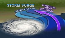
Regional Specialized Meteorological Centre (RSMC)
Regional Specialized Meteorological Centre (RSMC)... |
||
|
Multi hazard Vulnerability Mapping
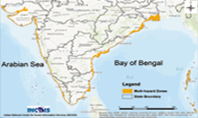
The Multi-Hazard Map is a "composite, synthesized and overlay ... |
||